One of the things that I enjoyed hearing about earlier this year was the Murrieta Creek Regional Trail Project.
This will stretch 17 miles from Temecula to Lake Elsinore.
City Engineer Dan York will be giving a power point presentation about the project. I've seen the pdf file and it's very comprehensive, but here are a few key slides to give you an idea of what's on the table.
 |
| Here are two views of the same area being discussed. The first is a general map, the second shows nearby trails. |

Allow me to retype what is on the slide
- Isolated segment of existing DG trail developed along the western levee of Murrieta Creek.
- Beginning of asphalt surface trail developed along the eastern levee of Murrieta Creek.
- View of the Murrieta Creek corridor looking south beyond future Temecula Parkway bridge.
- Existing asphalt surface multi-use trail running adjacent to Diaz Rd.
- View of the confluence area of Murrieta Creek and Santa Gertrudis Creek.
- Bridge at Rancho California Road crossing over the Murrieta Creek corridor.
- Facilities at Rotary Park, including parking, playgrounds and picnic areas, provide an opportunity to establish a formal trailhead.
- View of trail intersection at Rancho California Road.

- Informal natural surface trail along Murrieta Creek near Vineyard where future proposed levee trail will be developed.
- Existing DG trail segment runs along Murrieta Creek corridor to the end of Sykes Park.
- The Murrieta Equestrian Park represents one of the few equestrian staging area opportunities for Murrieta Creek Trail users.
- View of Kalmia St as it crosses Murrieta Creek.
- Small greenbelt adjacent Murrieta Creek just off of Kalmia at Calle Estancia.
- Critical creek crossing point from existing DG trail segment into Copper Canyon Park.
- View of the B St bridge as it crosses over the Murrieta Creek corridor.
- Existing steel frame bridge across Murrieta Creek inlet.
- View of locked gates where the creek inlet meets Grand Ave.
- Looking west across Union St to concrete lined creek inlet.
- Looking west at trail entry point off McVickar St.
- Existing segment of DG multi-use trail along a portion of Grand Ave.
- Existing shade structure at trail entry point at western end of Gruwell St.
- View of Gruwell St as it crosses over the Murrieta Creek corridor.
- View of Central St as it crosses over the Murrieta Creek corridor.

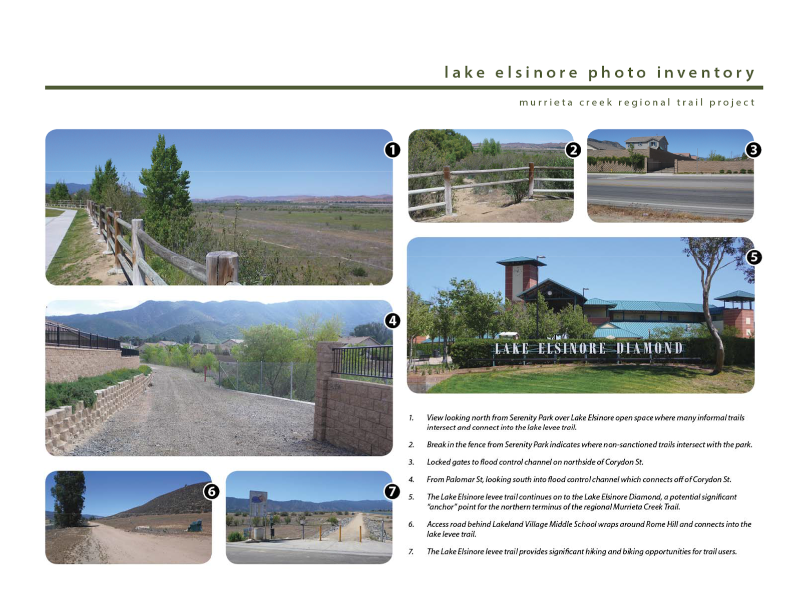
- View looking north from Serenity Park over Lake Elsinore open space where many informal trails intersect and connect into the lake levee trail.
- Break in the fence from Serenity Park indicate where non-sanctioned trails intersect with the park.
- Locked gates to flood control channel on northside of Corydon St.
- From Palomar St, looking south into the the flood control channel which connects off of Corydon St.
- The Lake Elsinore levee trail continues on to the lake Elsinore Diamond, a potential significant "anchor" point for the northern terminus of the regional Murrieta Creek Trail.
- Access road behind Lakeland Village Middle School wraps around Rome Hill and connects into the lake levee trail.
- The Lake Elsinore levee trail provides significant hiking and biking opportunities for trail users.
------------------------------------------------------------
I was asking Dan about this and learned that this has the National Parks and the Sierra Club on board with it. Though it would take time to complete, there is a one year goal for connectivity.
Come on out to city hall and learn more this Wednesday. Meeting starts at 6:30PM but you may want to get there fifteen minutes earlier than that.
+++++++++++++++++++++++++++++++++++++++


No comments:
Post a Comment
Let's hear what you have to say... for other inquiries try the email listed under "view my complete profile" but if you want to discuss a blog topic, I'll only do it in this comment section, not by email.